The Milwaukee area has been a crossroads for travelers throughout its history as an inhabited place. Milwaukeeans and their goods have gotten around by foot, horse, and engine power, using transportation technologies ranging from wheeled wagons to trains, streetcars, automobiles, busses, boats, and ships. Milwaukee’s transportation routes link people together within the region and to places far outside the state of Wisconsin.
Milwaukee’s location on Lake Michigan and the confluence of three rivers made it an attractive home to Native Americans. Indian trails followed the major rivers to and from Lake Michigan. Indians walked to harvest nuts, roots, and berries and to hunt. They also fished and traveled inland to visit other communities. In the nineteenth century, trail routes linked lakeshore tribes south with the Illinois and north with the Potawatomi. A few Indian trails later evolved into major streets such as Green Bay, Fond du Lac, and Forest Home Avenues.[1]
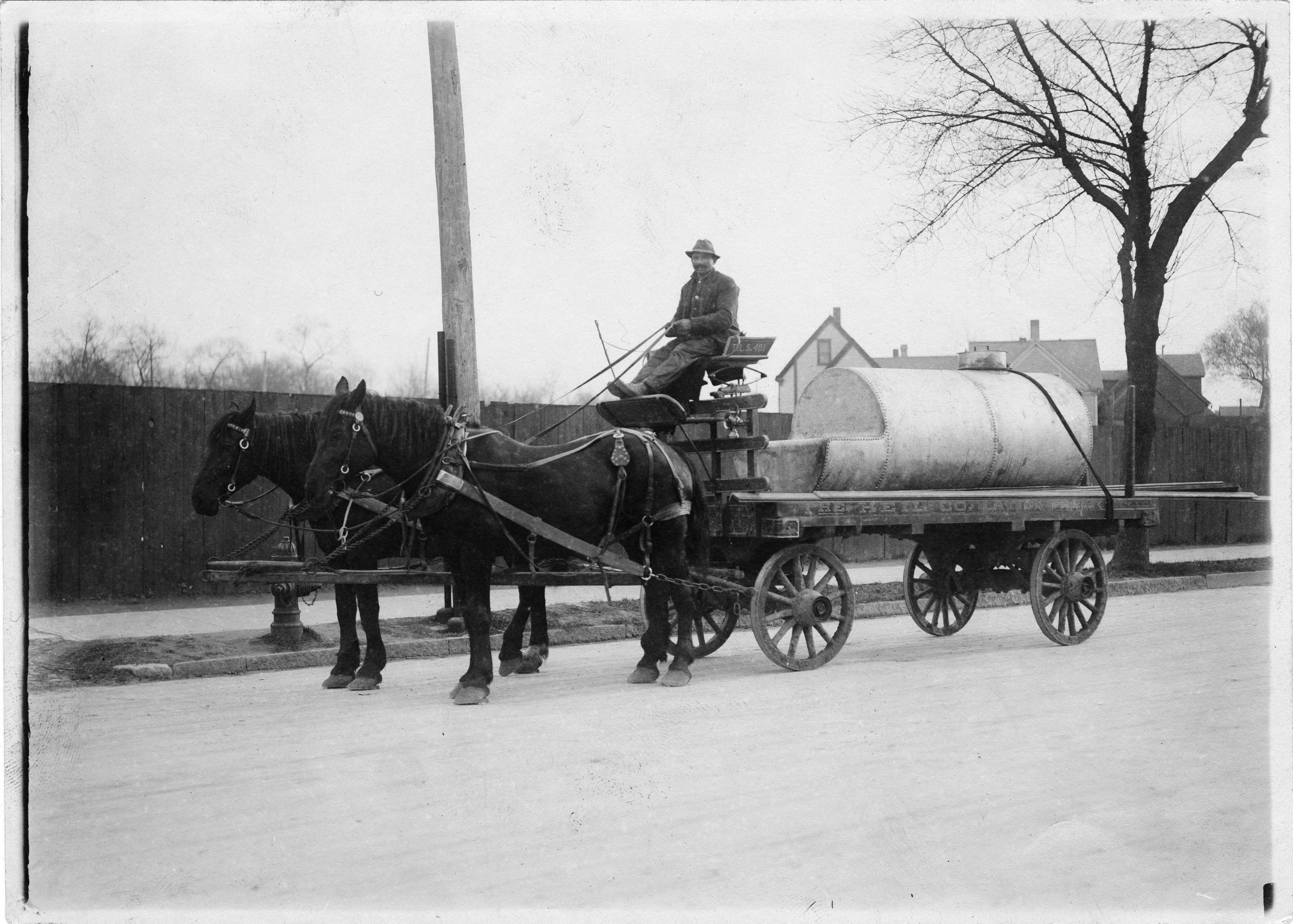
White settlers followed these Indian trails, widening and smoothing them for wagons and carriages. In the 1840s, private interests built wooden plank roads to speed transit. The Watertown Plank Road, connecting Milwaukee and Watertown, was begun in 1848 and completed in 1853. In the early 1850s, numerous privately built plank roads linked Milwaukee to its hinterland in a wheel and spoke orientation. Wisconsin chartered these privately-built roads, and the owners profited from toll charges. Merchants and farmers transported goods on these roads between Milwaukee, Chicago, Madison, and Green Bay. Some of these plank roads formed the basis for the modern diagonal roads that break up the city’s prevailing grid system.[2]
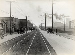
The city’s first railroad began operating between Milwaukee and Waukesha in 1851. The initial 20.7 mile line was named the Milwaukee and Mississippi Railroad, pointing to its ultimate destination, which it reached in 1857. A rail line reached Minneapolis-St. Paul in 1867, while Milwaukee was connected to Chicago by lines completed in 1855 and 1873. With these rail connections, the Menomonee Valley became the center of railroad activity, the place where goods and people boarded Great Lakes ships and where rail cars were built and serviced. The railroad made Milwaukee a major center of wheat, corn, lumber, and coal transit. Although Chicago’s rise as a rail hub diverted some of the inland agricultural commodities to that city, Milwaukee’s cross-state railroad lines helped the city maintain an important position in the Upper Midwest for grain and coal shipping into the 1870s.[3]
Throughout the twentieth century, people traveled to and from Milwaukee on railroads. Amtrak’s Hiawatha service between Chicago’s Union Station and Milwaukee began in 1971, terminating at the downtown train station. Following the recession of 2008, a high-speed rail proposal surfaced during Wisconsin Governor Jim Doyle’s administration. Plans called for upgrading the Chicago-Milwaukee Amtrak route and utilizing new high-speed trains built by the Spanish manufacturer Talgo in Milwaukee. However, Governor Scott Walker and the Republican legislature killed the plan in 2011, arguing that the state would end up bearing too much of the cost.
Railroads combined with the Port of Milwaukee to make the city a center for moving freight as well as people. Milwaukee’s role grew from the city’s location along Lake Michigan and proximity to an agricultural hinterland in the upper Midwest. Milwaukee became an important port for shipping grain grown in Wisconsin to the east. Milwaukee’s railroad network facilitated the rise of heavy industry, as machinery and other equipment built in the city was sent around the United States. The opening of the St. Lawrence Seaway in 1959 spurred an increase in bulk shipping, as it gave Milwaukee a direct transportation link to the East Coast and to Europe. Freight moved from the inland communities via the railroad to Milwaukee’s shipping harbor. Bulk goods were unloaded in the lower Menomonee Valley. There it was stored or processed and transferred onto ships. Wheat and corn were the largest commodities in the nineteenth century. Lumber and coal also arrived at the port from the other parts of the Great Lakes region and transferred to the rail lines.[4] In the 1950s, the Canadian Pacific Railway and the Union Pacific Railroad connected the Midwest to the Port of Milwaukee with railyards in the Menomonee Valley.
Streets, roads, and boulevards
The federal land survey’s grid pattern formed the basis of several of Milwaukee’s original major streets, including Juneau Avenue, North Avenue, Burleigh Street, and Capitol Drive, among others. Milwaukee’s streets therefore follow a typical grid pattern, with one wrinkle. In the 1830s, land speculators laid out different grids on either side of the Milwaukee River. The two grid systems do not line up and, as a result, downtown bridges cross the river at a sharp angle.[5] Other notable road features in Milwaukee include the four viaducts (at 6th Street, 16th Street, 27th Street, and 35th Street) that pass over the Menomonee Valley and connect the city’s North and South sides. Milwaukee’s road system developed further in the 1920s, when park planner Charles B. Whitnall laid out a series of parks and parkways that followed the city’s rivers and the city built Lincoln Memorial Drive along the Lake Michigan shoreline.[6] Lincoln Memorial Drive was part of a large landfill project that helped alleviate flooding and prevented erosion of the lake bluff, a perennial problem. Lincoln Memorial Drive remains a major street, connecting the East Side of Milwaukee to the Hoan Bridge and to the Lake Parkway (I-794).
Streetcars and Buses
Walking and horse-drawn carriages dominated Milwaukee’s transportation from the 1840s to the 1860s. In 1860 streetcars pulled by horses began operating along Water Street.[7] In 1890, the first electric streetcar line ran along West Wells Street. In 1896, several private streetcar companies merged to form the Milwaukee Electric Railway and Light Company (which was shortened both to TM and TMER&L). A subsidiary of TMER&L, the Milwaukee Light, Heat, and Traction Company, ran interurban commuter lines to Kenosha, Sheboygan, Watertown, Burlington, and East Troy. By 1917, the TMER&L lines connected downtown to the South, West, and North sides, with a concentration on Wisconsin Avenue and Wells Street.[8] TMER&L ran gasoline-powered buses on W. Mitchell Street beginning in 1920 and then began replacing electric streetcars with buses that allowed more flexibility and cost savings. The first overhead electric lines powering “trackless trollies” began operating in 1936 along North Avenue. By 1938 a streetcar line, trolley, or motor bus ran on nearly every major Milwaukee street.[9] In the 1950s, diesel buses began replacing electric streetcars. The streetcars ran until 1958, and electric trolley buses ran until 1965.[10]
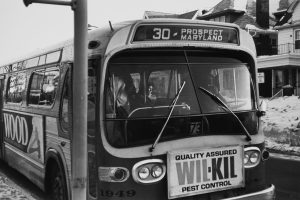
By the 1960s, the gasoline and diesel buses connected the city to the suburbs. In 1964, the Milwaukee and Suburban Transport Corporation introduced the first of a fleet of freeway flyers that would eventually link the city to shopping centers in Ozaukee, Waukesha, and Washington counties. The agency that later became the Milwaukee County Transit System (MCTS) brought county control to the privately-owned bus lines in 1975. Buses also carry suburban passengers from park and rides to events like Summerfest and the Wisconsin State Fair.[11]
As MCTS faced funding shortages in the early 2000s, fare increases and route reductions became necessary. Ridership declined by ten million between 2000 and 2007, partly due to cutbacks on frequency of service and routes. County voters approved a ½ cent sales tax increase to support the system in 2008, but the state legislature blocked collection of the tax.[12] In 2008, MCTS was ranked the most cost-effective transit system among its peers.[13] In 2016, Milwaukee County and MCTS began planning a 9-mile, $50 million bus rapid transit system to connect city residents to jobs along the route, including at Marquette University and the Milwaukee Regional Medical Center in Wauwatosa, the location of Froedtert and the Medical College of Wisconsin. If implemented, a dedicated bus lane will run along Wisconsin Avenue and Bluemound Avenue and have nineteen stations.[14] Badger Bus linked Milwaukee to Madison in 1946, running gasoline buses to and from a bus depot in downtown Milwaukee on 6th Street until moving to the Intermodal Station in 2016. Wisconsin Coach Lines began in 1941 and now runs between Milwaukee Mitchell Field, Chicago’s O’Hare Airport, and Waukesha.
Freeways
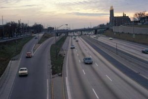
As post-Second World War Milwaukee’s downtown became congested, city leaders pushed for highway construction. Hoping to compete for suburban shoppers, downtown department store owners assumed that expressways would lure suburbanites downtown, while state officials believed better transportation through Milwaukee would help Wisconsin’s economic growth. In 1944, Milwaukee, with state and county assistance, produced the “1946 Origin-Destination Survey,” which became the basis for the city’s expressway system. In 1948, Milwaukee voters passed a referendum providing $5 million in bonds to pay for expressways and other road improvements. On March 17, 1952, construction began on the Stadium Freeway, and in 1953 a 2,200 foot section was completed along South 43rd Street near the new Milwaukee County Stadium. In November 1953, the Wisconsin state legislature created a five-member Milwaukee County Expressway Commission (MCEC). The commission was responsible for planning and constructing the freeway system in coordination with city, county, and state officials. On February 24, 1955, the MCEC released a plan for a highway system that estimated $221 million in construction costs. In 1956, the passage of the Federal Interstate Highway Act provided federal money to pay for 90 percent of the cost of the freeway system.[15]
The city’s geographic location largely determined the basic freeway layout. One major north-south artery (I-43) ran parallel to Lake Michigan and linked Chicago and Green Bay by passing through Milwaukee. Another east-west artery (I-94) linked Milwaukee and Madison (I-94). Besides these two basic freeways, other freeway routes proved much more controversial. Some projected routes ran through city neighborhoods, inspiring intense residential opposition. In the late 1960s and 1970s Milwaukee’s anti-freeway movement blocked completion of the freeway system. Activists stopped the building of a loop freeway around the downtown and along the lakefront, blocked the completion of the Stadium Freeway (now state highway 175, it ends at National Avenue on the south and Lisbon Avenue to the north), and limited the scope of another link to the short I-794, which provides access to and from the Hoan Bridge.
Milwaukee’s current freeway system has three main branches. A northern branch connects the city to Green Bay, the western branch to Madison, and a southern branch to Racine, Kenosha, and Chicago. The three branches merge in the Marquette Interchange, the busiest interchange in the state. The Marquette Interchange, named for the nearby university, is located in downtown Milwaukee. It was built in the 1960s and reconstructed with significant improvements between 2004 and 2008. Growth of suburbs to the north, west, and south resulted in the completion of Interstate 894, a beltline that intersects with Interstate 94 at the so-called Zoo Interchange in Wauwatosa. The Zoo Interchange was built in 1963 and began to be remodeled in 2016. The current freeway system is well beyond its intended capacity, and several widening projects are underway. But I-94 passes through a veterans’ cemetery that makes widening particularly controversial. Funding shortages have required the state to slow down freeway expansion in recent years. The legislature has not raised the gasoline tax, which helps pay for freeway construction, since 2006.[16]
Bike lanes
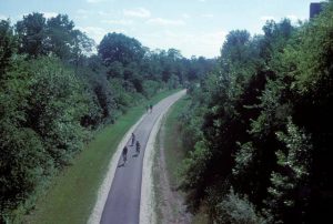
Despite the difficulties of winter weather, Milwaukee’s relatively flat geography, compact size, mild summers, and prevalence of parks make it well suited for bicycling. In 1939, a sixty-four-mile bike trail was proposed to connect the city’s parks. Milwaukee County added to that trail, creating the 76-Mile Trail, which was later renamed the Oak Leaf Trail.[17] Much of the Oak Leaf Trail runs on abandoned rail lines converted for bicyclists. The trail now connects the city and the suburbs and is over 111 miles in length. The Hank Aaron State Trail links the East Side and downtown to the Milwaukee Brewers’ baseball stadium in the Menomonee Valley and continues to the west past the Wisconsin State Fair Grounds, ending in Wauwatosa. Critics have recently raised the issue of the racial disparity in the location of the trails, with little of the mileage in areas where non-white residents live. Milwaukee is headquarters for the Bike Federation of Wisconsin, which publishes bike trail maps, puts on bike events, and advocates for improved roads and more bike lanes and for laws protecting bicyclists.[18]
Milwaukee’s Airports
The first Milwaukee county airport, Butler Airport, opened in 1919 in Currie Park. However, it had limited space for expansion. In 1920, a 162-acre private airstrip, Hamilton Field, opened just west of Cudahy. In 1926, the Milwaukee County bought the airstrip and renamed it the Milwaukee County Airport, and Northwest Airlines began offering flights to Chicago and Minneapolis/St. Paul. Another airstrip, Maitland Field, opened in 1926, at the current Henry Maier Festival Park. It was named after Lester J. Maitland, who piloted the first transpacific flight between California and Hawaii in 1927. The airfield closed in 1956 and became a Nike missile site. In 1929 another airfield opened at the corner of Appleton and Silver Spring, which in 1947 became Timmerman Airport.[19]
In 1941, Milwaukee County Airport was renamed “General Mitchell Field” after the World War II aviation hero, William “Billy” Mitchell. The opening of a U.S. Customs office in 1986 led to another name change: General Mitchell International Airport. The development of the I-94 freeway made the trip to Milwaukee for air travel convenient for customers from Chicago and its northern suburbs. Convenience increased when an Amtrak station opened at the airport in 2005. Mitchell International became the headquarters for Midwest Express in 1984. Midwest Express began as a regional airline and later expanded service to the West Coast and Florida. It built a reputation for comfortable travel with amenities that included chocolate chip cookies baked during the flight. Midwest Express had its hub in Milwaukee until 2010, when it merged with Frontier Airlines. In 2002, AirTran began flying out of Mitchell International, a service that lasted until the company was purchased by Southwest Airlines in 2011. Southwest started operating out of Mitchell International in 2009 and is now the airport’s largest carrier. In March of 2017, a low-cost Mexican airline, Volaris, began operating nonstop flights from Mitchell International to Guadalajara, evidence of the growing Mexican population in the city and region.[20]
The New Downtown Streetcar
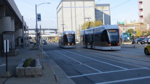
In 2017, the city of Milwaukee began construction on a light rail streetcar line nicknamed “the Hop,” which runs in a loop around downtown. Planning for the streetcar began in 2009. The city used $55 million in federal money and a tax incremental financing district (TIF) to finance a 2.5-mile long line connecting downtown, the intermodal train-bus station, the Third Ward, and the lakefront. In 2016, the city asked for but was denied federal funds for a one-mile extension to Fiserv Forum, the new Milwaukee Bucks arena opened in 2018. Instead, the city will use TIF money to pay for the expansion to the arena. Republicans in the Wisconsin legislature opposed the streetcar line and attempted to undermine the project, claiming that eventually local taxpayers would face obligations to pay maintenance and operational costs. Brookville Equipment Corporation in Pennsylvania built the streetcars. In 2017 Milwaukee County awarded the operational contract to Transdev to operate and maintain the five Brookville Liberty Light Rail Vehicles. The Hop began running in fall 2018, with Potawatomi Hotel and Casino sponsoring free rides for its first year.[21]
Footnotes [+]
- ^ John Gurda, The Making of Milwaukee (Milwaukee: Milwaukee County Historical Society, 1999), 9; Harold M. Mayer, “By Water, Land, and Air: Transportation for Milwaukee County,” in Trading Post to Metropolis: Milwaukee County’s First 150 Years, ed. Ralph M. Aderman (Milwaukee: Milwaukee County Historical Society, 1987), 325-326.
- ^ Gurda, Making of Milwaukee, 80-81.
- ^ Gurda, Making of Milwaukee, 81-86; Mayer, “By Water, Land, and Air,” 331-333.
- ^ Mayer, “By Water, Land, and Air,” 332-333.
- ^ Mayer, “By Water, Land, and Air,” 334.
- ^ Gurda, The Making of Milwaukee, 268-272.
- ^ Christopher Miller, “Transportation Technology,” Milwaukee History 25, no. 3/4 (2002): 69; Gurda, The Making of Milwaukee, 88.
- ^ See the 1917 map in Transit in Milwaukee—History, Chicago Rail Fan website, last accessed February 16, 2019.
- ^ See 1938 map in Transit in Milwaukee—History, Chicago Rail Fan website, last accessed February 16, 2019.
- ^ Ken Smith, “A Short History of Milwaukee’s Old Streetcar System,” Urban Milwaukee, March 31, 2015, last accessed February 16, 2018.
- ^ “Transporting People: A History of Public Transportation in Milwaukee County,” Milwaukee History, 22, no. 3/4 (1998), 54-61.
- ^ “Transit Is a Tool That Needs Sustainable Funding Source,” Milwaukee Journal Sentinel, July 7, 2012, last accessed February 16, 2019.
- ^ “Milwaukee County’s Transit Crisis: How Did We Get Here and What Do We Do Now?,” (Milwaukee, Public Policy Forum, 2008), 26, last accessed March 5, 2018.
- ^ Preferred Route for East-West BRT, East West BRT website, last accessed February 16, 2019.
- ^ Gregory Dickenson, “Through Highways: Construction of the Expressway System in Milwaukee County, 1968-1977” (MA thesis, University of Wisconsin-Milwaukee, 2015), 23.
- ^ Milwaukee Freeways, Wisconsin Highways website, last accessed February 16, 2019.
- ^ Oak Leaf Trail, Wikipedia, accessed March 7, 2018.
- ^ For bike trail maps, see Milwaukee Bike Maps, Department of Public Works, City of Milwaukee website, last accessed February 16, 2019.
- ^ Mayer, “By Water, Land, and Air: Transportation for Milwaukee County,” 361-367.
- ^ History, Mitchell International Airport website, last accessed February 16, 2019.
- ^ The Milwaukee Streetcar website, https://www.themilwaukeestreetcar.com/, accessed 2018, now available at https://web.archive.org/web/20180307211643/https://www.themilwaukeestreetcar.com/, last accessed February 16, 2019; now see The Hop Streetcar website, last accessed February 16, 2019.
For Further Reading
Behling, Reis. “The Watertown Plank Road.” Historical Messenger of the Milwaukee County Historical Society (June 1954): 10-13.
Casey, James J. Mayor Frank P. Zeidler: Transportation Development in Post-War Milwaukee. Kansas City, MO: APWA Press, 2006.
Derleth, August William. The Milwaukee Road: Its First Hundred Years. Iowa City, IA: University of Iowa Press, 2002.
Hardie, George A., Jr. Milwaukee County’s General Mitchell International Airport. Milwaukee: Friends of the Mitchell Gallery of Flight, 1996.
McShane, Clay. Technology and Reform: Street Railways and the Growth of Milwaukee, 1887-1900. Madison, WI: State Historical Society of Wisconsin, 1974.
Moore, Karen W. “Missed Connections: The Progressive Derailment of Public Transit in Metropolitan Milwaukee during the Electric Street Railway Era.” PhD diss., University of Wisconsin-Milwaukee, 2011.
Moore, Karen W. “State Impediments to Transit-Centered Planning in Milwaukee, Wisconsin, 1916-1928.” Journal of Urban History 40, no. 2 (2014): 318-44. doi:10.1177/0096144213508627.
Scribbins, Jim. The Hiawatha Story. Minneapolis, MN: University of Minnesota Press, 2007.
Scribbins, Jim. Milwaukee Road Remembered. Minneapolis, MN: University of Minnesota Press, 2008.
0 Comments
Please keep your community civil. All comments must follow the Encyclopedia of Milwaukee Community rules and terms of use, and will be moderated prior to posting. Encyclopedia of Milwaukee reserves the right to use the comments we receive, in whole or in part, and to use the commenter's name and location, in any medium. See also the Copyright, Privacy, and Terms & Conditions.
Have a suggestion for a new topic? Please use the Site Contact Form.