The term placemaking can be confusing because different stakeholders understand it in various ways.[1] Sometimes people refer to placemaking’s economic development functions; at other times, the emphasis is on cultivating city residents’ creativity. According to urban planner Mark Wyckoff, placemaking is simply a “process of creating quality places that people want to live, work, play and learn in.”[2] Project for Public Spaces, a non-profit, planning, design and educational organization, defines placemaking as “a collaborative process by which we can shape our public realm in order to maximize shared value.”[3] Arts professionals have a different definition. Ann Markusen coined the term “creative placemaking” to describe a collaborative process where multiple stakeholders such as public, private, not-for-profit, and community sector actors strategically reshape their physical and social worlds through art and cultural practices in ways that are primarily economically productive.[4] However, even among artists there are alternate references to this term. Artists practicing socially-engaged, participatory art tend to focus on the aesthetic and collaborative nature of this process rather than on economic benefits. They argue placemaking empowers lay citizens to contribute to their environment and transform it.[5]
In Milwaukee, media commentators and institutions such as the Greater Milwaukee Committee (GMC) and Local Initiatives Support Corporation (LISC) use the term placemaking to describe collaborations over local development projects through public-private partnerships.[6] Referring to art projects such as “Listening to Mitchell” (Sonja Thomsen and Adam Carr, artists), “Islands of Milwaukee” (Anne Basting, lead artist), ARTery (Beintween, Keith Hayes, artist), and Riverwest 24 (a community-organized bike race), Journal Sentinel reporter Mary Louise Schumacher explains, placemaking “involves artists using places as both a subject and medium. They are making work directly in the urban landscape.” But, she continues, “Suspicions run especially high when placemaking is driven by economic development interests, what’s often dubbed ‘creative placemaking’ for some reason. In practical terms, that means organizations such as the Greater Milwaukee Committee, certain developers such as the Mandel Group and the City of Milwaukee itself come to the table with specific goals and then invite creatives into the process.” [7]
This essay proposes that we think of placemaking as a transformation of our material world at multiple social, geographical, and time scales.[8] We should consider the macro scale of environmental history, the historical scope of social histories of neighborhoods and buildings at an urban scale, and the making of our nearby environment by ephemeral everyday actions at the micro scale. This expanded definition incorporates the impact of both human and non-human agents in the making of our material world.
Placemaking as a Slow Process
In order to understand placemaking as an environmental process, consider Milwaukee’s foundation in water. Milwaukee grew from a core located between Lake Michigan and the water catchment areas of three riverine systems, the Milwaukee, Kinnickinnic, and Menomonee rivers. Increase Lapham’s maps from the mid-nineteenth century show wetlands, woodlands, and grasslands separated by these converging rivers.[9] This ecosystem, covered with forests of sugar maples, basswood and beech, is not visible in today’s neighborhoods of the Third Ward, Jones Island, Walker’s Point, and Bay View. But as John Gurda explains, “A broad finger of the central marsh reached into the interior, filling the Menomonee Valley as far west as Forty-Third Street,” giving shape to the city that followed.[10] Many diagonal roads that break the contemporary city’s orthogonal grid also stand as testimony to this history. Natives—mostly Potawatomi, but also a mix of Sauk, Ottawa, Ojibwe, and Menominee—left effigy mounds and cleared ground for villages. According to Mary Louise Schumacher, effigy mounds are “subtle contours in the landscape.” They “are our state’s most enduring form of public art.”[11] Archaeologists argue that these elaborate earthen mounds may have been sacred burial grounds or “cosmological maps” that reflect the social belief systems of native societies.[12]
According to Gurda, trails and transportation routes from this period predate some of our current streets. For example, Gurda says that the “Green Bay trail, which roughly paralleled today’s Green Bay Avenue, was so popular that it was worn to a depth of nearly two feet.”[13] The name Milwaukee too harkens back to that past, for the term arguably means “good land” and reflects a resource-rich soil and a water-based ecology.[14]
Milwaukee’s location by the lake also determined how the city grew as a port. With a wide bay and a deep river mouth, Milwaukee could accommodate ships from the lake.[15] In the years after the American Revolution, Milwaukee’s location on Lake Michigan slowly made it a trading post for white fur traders. Later, in 1818, Solomon Juneau traded with local Amerindian tribes whose landownership became tenuous under the onslaught of American troops—an important political moment in the making of Milwaukee as a place.[16]
The federal Public Land Survey System following the Land Ordinance of 1785 divided the Milwaukee region into sections measuring one square mile. These original section lines correspond to many contemporary major arterials, such as Juneau Avenue, North Avenue, Capitol Drive, Greenfield Avenue, Lincoln Avenue, Oklahoma Avenue, and 27th Street. But despite the organizing logic of the grid, the north-south lay of the Milwaukee River divided the settlement into two parts—one side abutting the lake and the other side connecting to the hinterland beyond. This east-west orientation framed speculative real estate activities between 1835 and 1846. Morgan Martin, Solomon Juneau, Byron Kilbourn, and George Walker set up separate settlements (Juneautown, Kilbourntown and Walker’s Point, east, west, and south of the river respectively). Martin’s and Juneau’s choice of lakeside properties, or along the eastern edge of the river, reflected their hope that the lakefront would dominate future development in Milwaukee. Kilbourn, however, remained convinced that his land on the western side would spur trade and growth with clear access to cities such as Chicago and Green Bay.[17] The shifted urban grid on the opposite banks of the Milwaukee River remains a material marker of a past that framed subsequent placemaking activities.
Placemaking as Cultural Process
A time scale of the last 160 years of Milwaukee’s growth shows how actions of larger institutions such as industry and the city, state, and federal governments shape placemaking. This section examines how more recent kinds of placemaking reproduce markers of cultural and social memory in the urban environment.
The neighborhoods in the city of Milwaukee are often defined by cardinal directions—West Side, East Side, North Side, and South Side. Geographer Judith Kenny writes that “although the ‘city of neighborhoods’ title has not been adopted for any official purpose, few Milwaukeeans describe their city without detailing the variety and significance of neighborhoods in their hometown.”[18] Kenny describes four historical periods of growth that may explain how these neighborhoods developed over time. Her periodization helps us see that placemaking is a historical process influenced by the zeitgeist of social, political, and economic forces framing urban growth since the industrial era.
By 1881 a strong industrial economy, with breweries, metal fabrication factories, and tanneries, carved out a settlement pattern predominantly defined by residents’ class and ethnicity.[19] Working-class neighborhoods were segregated by the national origins of foreign-born residents. Neighborhoods located on the north and northwest sides of downtown were predominantly German, while the South Side housed Polish groups clustered around parochial Catholic churches.[20] Distinctly upper- and middle-class neighborhoods developed along Lake Michigan’s shores, producing the East Side and the “Gold Coast.” The East Side and Yankee Hill neighborhoods drew wealthier residents, who built large mansions such as those along the appropriately named Prospect Avenue. These neighborhoods grew simultaneously, their futures inextricably linked but their boundaries painstakingly policed and physically delineated.
A series of building types further marked this landscape into distinct residential districts and industrial neighborhoods. For instance, church steeples marked the religious roots of the city and gave identity to the residential neighborhoods on the South, West, and East sides. Even today, Saint Hedwig’s on Brady Street, Saint Michael’s on 24th Street, St. Anthony’s on Mitchell Street, and the Basilica of St. Josephat on the South Side of the city serve as spatial landmarks. Large warehouses mark industrial districts such as Walker’s Point, the Third Ward, and the Menomonee River Valley. The brewing industry produced its own ecology, with complexes such as the Pabst, Schlitz, Miller, and Blatz breweries and associated retail outlets such as bars, clubs, taverns, and tied houses.[21] Residential building types such as the duplex and triplex cottages and Polish flats were popular in working-class neighborhoods located on the North and South sides. Constructing a world around symbolic buildings is part of any placemaking process.
Most current discussions of placemaking erroneously focus on small scale changes such as community art and development projects, while ignoring the powerful role played by local, regional, state, and federal institutions in constructing social and physical worlds. The story of placemaking in the twentieth century serves as a corrective, demonstrating how multiple stakeholders with different self-interests transformed the cityscape. Starting in the 1920s, the automobile and demographic changes encouraged suburbanization among Milwaukee’s white population. Government policies played a big part in this demographic restructuring. In addition, between 1946 and the mid-1960s, Milwaukee went through rapid growth and land annexation. Large infrastructure projects funded by the federal, state, and local governments also shaped the city’s landscape.
Consider the making of the Milwaukee lakefront. Until the 1930s, many lakefront properties extended right up to the edge of Lake Michigan. For example, Lloyd Smith, the president of A.O. Smith Corporation, owned a grand lakeshore mansion (now the Villa Terrace Decorative Arts Museum). In 1920, the City of Milwaukee began to infill the shores of Lake Michigan. By 1929, with the construction of the Lincoln Memorial Drive, a large stretch of infill produced a publicly accessible lakefront. With this road’s construction, the water’s edge was separated from the borders of private properties such as Smith’s home, creating an artificial lakefront and an exceptional public urban space.
Large federal New Deal projects furthered the development of a rich network of parks and leisure spaces that cut across the cityscape. Examples of such projects included the Brown Deer Park Pavilion, Estabrook and Washington Park improvements, additions to Lincoln Park, the bathhouse and pool at Lapham Park (now Carver Park), and Silver Spring Park (now McGovern Park).[22] The federal Public Works Administration constructed Parklawn, the first public housing project during the 1930s. By 1952, the Milwaukee Housing Authority also built Northlawn, Southlawn, and Berryland to provide housing for World War II veterans.[23]
Large scale demographic changes shaped notions of place among residents. The city of Milwaukee became geographically segregated, with the West and North sides majority African American, the South Side Hispanic, and the East Side mostly Anglo American. The period between 1956 and 1960 saw a rapid increase in the number of African American residents, concentrated on the north side. The old Polish Catholic neighborhoods on the South Side were repopulated by Spanish-speaking Mexicans and Latino residents.[24] After World War II, urban renewal and highway projects, racist redlining practices, and housing loan schemes exacerbated segregation as economic disinvestment ravaged the majority black neighborhoods.
Placemaking as a Fleeting Process
At a more micro scale, placemaking focuses on the role of the human body as it engages the sensate world, the daily rhythms of the streets, day and night, domestic activities, neighborhood politics, and seasonal events. Individuals’ emotions, memories, and experiences—inflected by their language, class, religion, and gender—frame how they act in place and mark their landscape in more nuanced, if ephemeral, ways. Therefore, to understand placemaking fully, one must focus on everyday corporeal experiences, including those that seem banal and habitual.
Ephemeral reimaginings of public spaces during parades and protests are examples of placemaking as a fleeting process. Examples include labor unrest in the nineteenth century, takeovers of streets during labor strikes of the 1886 and the 1896 streetcar strikes, and the fair housing marches of 1967.[25] More recently, Occupy takeovers, Black Lives Matter protests, political rallies, and artistic demonstrations by groups such as the Overpass Light Brigade demonstrate how placemaking can support social action and nurture community memory. Annual festivals and events such as Milwaukee’s Summerfest, lakeside summer and ethnic festivals, ARTery social initiatives by Beintween and Creational Trails, and Alverno College’s Global Union also count as transient placemaking.[26]
Placemaking is a political and contested process. An example of contested placemaking played out on the banks of the Milwaukee River. A public-private partnership gentrified the area from its industrial use into its thriving contemporary avatar, including new residences, leisure spaces, and retail and commercial enterprises.[27] By 2000, new residential condominiums and recreational trail developments had physically, visually, and demographically transformed the section along the Milwaukee River between Humboldt Avenue and Juneau Avenue. As part of this redevelopment, the 2006 Edward D. Holton Marsupial Bridge was hailed as an exemplar public placemaking project that used the existing infrastructure under the Holton Street Viaduct over the river.[28] The site, despite its design awards and intentions, remained underused until 2012, when a group of young architects and local residents planted a few makeshift swings in the plaza abutting the bridge. The creation of this simple “swing park,” done overnight, was very popular among local residents and children. [29] However, this insurgent move was highly debated. Designers and other commentators criticized the swing park for transforming the space without approval from the original architects. This transformation challenged traditional responses to questions such as “what is beautiful?” and “who produces art?”[30] and revealed the disparate roles and divergent self-interests of architects, art critics, local politicians, city bureaucracy and departments, artists, and local residents in placemaking.
As a form of grassroots resistance, placemaking produces innovative uses of space and new kinds of urban sites. We see this in the urban gardens that appeared in inner city neighborhoods in the twenty-first century. Gardening actions of non-profit organizations such as the Walnut Way Conservation Corp., Sweet Water Organics, and Growing Power transformed city empty lots into urban gardens and community gardening spaces. These gardens encourage wholesome food options and opportunities such as farmers’ markets and cooking demonstrations. The fertile land produced by the riverine system and associated ecological conditions that impacted the initial settling of Milwaukee also made agriculture a viable option for economic development, grassroots engagement, and local food provision in the twenty-first century.
Between 2006 and 2015, Hmong and African American residents and “micro-farms” such as the Cream City Farms transformed empty property lots into community gardens in neighborhoods such as Washington Park. These produce gardens are interwoven into a dense post-industrial urban fabric. The labor-intensive process of gardening, smells and sounds of urban gardens, the resultant increase in bees, butterflies, and fauna, and ultimately the transformation of food habits and food consumption practices produce radical changes. Although these changes seem small and local, they challenge industrial food production and modern food consumption patterns, promote human health and welfare, and positively transform the dilapidated physical landscape. For Hmong immigrants, who have prominent roles in the urban gardens and farmers markets, gardening serves as a cultural act of remembering their heritage.[31]
Artistic memorials, statues, murals, and graffiti suggest yet another mode of placemaking. The visual and material environments of art help remember and commemorate events, people and culture.[32] The State Historical Marker for the Bay View Rolling Mills (S. Superior St. and E. Russell Ave.), the marker commemorating Lueddemann’s-on-the River (on the current site of Shorewood’s Hubbard Park), and the plaque remembering the rescue of Joshua Glover (Cathedral Square Park) mark community histories on the urban landscape. Examples of public art commemorating people and historic figures include the Solomon Juneau Monument (1887) by American artist Richard Henry Park on the grounds of Juneau Park; the Victorious Charge (1898), a Civil War memorial by American artist John S. Conway located on the Court of Honor on West Wisconsin Avenue in downtown Milwaukee; the bronze equestrian sculpture of General Thaddeus Kosciuszko (1905) on South 9th Place and West Lincoln Avenue in Kosciuszko Park; and the Baron Friedrich Wilhelm von Steuben monument (1921) by J. Otto Schweizer at the intersection of West Lisbon Avenue, Lloyd Street, and North Sherman Boulevard. Such sculptures are part of the official histories, often produced and funded by the state and city institutions. Over time, they become important landmarks that orient Milwaukee residents, who habitually engage with urban art as they pass these artifacts. These momentary and fleeting experiences of art get internalized as memories of place, as urban landmarks, suggesting how placemaking influence human identity.
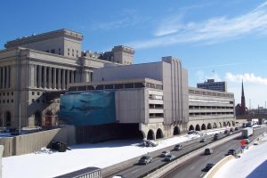
Murals painted on empty walls across Milwaukee may be considered acts of artistic placemaking.[33] Some remain as landmarks, while others have been removed. In 1997, artist Robert Wyland donated a 76×37 feet mural entitled the “Whale Commuters” to Milwaukee County. The mural was placed on the north façade of the Milwaukee County Courthouse Annex over the freeway. Similar murals were painted in multiple cities in at least eight countries.[34] In 2006, Milwaukee County Executive Scott Walker and the County Board of Supervisors ordered this mural demolished when they decided to take down the courthouse annex during renovation of the Marquette Interchange.
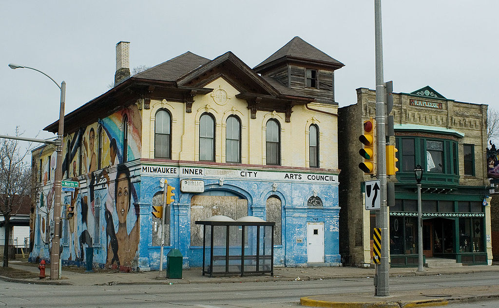
Murals by local artists speak of vernacular traditions and local histories. Muralists such as Reynaldo Hernandez, Ras ‘Ammar Nsoroma, Ramiro Sandoval Arguta, Raoul Deal, and Nicholas Lampert have generated community-engaged mural making as an art form. They have mentored a generation of local artists whose goal is to make public art that empowers local communities. Examples include Reynaldo Hernandez’s mural on the former Inner City Arts Council building at N. 7th St. and W. North Avenue (1984); Arguta’s Hummingbirds on 3313 W. National Avenue; George Gist’s Buffalo Soldiers mural (1993) on the Steel Professional Welding building, 2000 N. 31st Street; Alex and Chris Couto’s mask murals at the intersection of 1st Street and Pittsburgh Avenue; the Peacemakers mural at the intersection of Mitchell Street, Kinnickinnic Avenue, and First Street; Renaldo Hernandez’s mural (1993) on the Esperanza Unida International building, 611 W. National Avenue; Aztec Calendar (2010) by Ben Stark, Fred Kaems, and Natalio Lopez III on 3420 W. Vliet Street; Roberto Cisneros’ History of Latinos in Milwaukee mural on Bruce Guadalupe Community School; and Brad Bernard’s Victory over Violence (1997) on the wall of the Career Youth Development Center. Many of these examples of placemaking memorialize histories of underrepresented groups such as Latinos and African Americans and have become symbols of local identity and grassroots resistance against their systemic disenfranchisement.
Conclusion
Why should our approach towards placemaking take into account the multiple intertwined contexts of time and geographical scales? We often forget that a place exists within multiple nested geographies and is influenced by a variety of forces, including climate, government policies, cultural practices, and individual actions. Place is politically contested, experienced, and interpreted in more than one way. Hence placemaking is not a simple causal process. Instead it denotes the production of a site that is material and tangible not only by its physical characteristics, but also by much less explicit symbolic and socially constructed boundaries. Placemaking is implicated in everyday practices. The residents of Milwaukee—individual citizens, artists, activists, entrepreneurs, and politicians—operate within the context of larger political, economic, and governmental systems, making space for themselves, and often contradicting, resisting, and reimagining their material world. If larger forces such as the environment, government, industry and even the artistic community can recast the city into neighborhoods, districts, and locales, everyday embodied actions by individuals can also remake place in nuanced and alternative forms. Placemaking allows us to better understand the city as a living and dynamic space that is framed, contested, and incessantly transfigured.
Footnotes [+]
- ^ Lynda H. Schneekloth and Robert G. Shibley have traced the origins of the term placemaking to the phenomenological writings of Christian Norberg Schultz as well as to work by geographers such as Yi-Fu Tuan. These scholars refer to the human experience of place as discussed by philosopher Martin Heidegger but concentrate on the term’s experiential and symbolic aspects. They argue that the term placemaking even in this early context focuses on the engagement of the human body with the material world (physiological) and the individual’s investment of meaning, identity and sensory experiences (psychological). Lynda H. Schneekloth and Robert G. Shibley, Placemaking: The Art and Practice of Building Communities (New York, NY: Wiley, 1995); Christopher Alexander, Sara Ishikawa, and Murray Silverstein, A Pattern Language (New York, NY: Oxford University Press, 1977); Yi-Fu Tuan, Space and Place: The Perspective of Experience (Minneapolis, MN: University of Minnesota Press, 1977); Christian Norberg Schultz, Intentions in Architecture (Cambridge, MA: MIT Press, 1968); Lance Jay Brown, David Dixon, and Oliver Gillham, Urban Design for an Urban Century: Placemaking for People (New York, NY: Wiley, 2009); Edward Casey, The Fate of Place: A Philosophical History (Berkeley, CA: University of California Press, 2013); Ronald Lee Fleming, The Art of Placemaking: Interpreting Community through Public Art and Urban Design (London, UK: Merrell Publishers, 2007).
- ^ Mark A. Wyckoff, “Definition of Placemaking: Four Different Types” (East Lansing, MI: Michigan Land Policy Institute, January 2014), accessed December 7, 2015.
- ^ Cynthia Nikitin, “All Placemaking Is Creative: How a Shared Focus on Place Builds Vibrant Destinations” (New York, NY: Project for Public Spaces, n.d.), , accessed December 7, 2015; What is Placemaking?, Project for Public Spaces website, last accessed January 2, 2019.
- ^ Ann Markusen and Anne Gadwa, “Creative Placemaking” (The Mayors’ Institute on City Design, National Endowment for the Arts, Markusen Economic Research Services, and Metris Arts Consulting, 2010), accessed December 7, 2015. This term focuses on the economic impact of placemaking. Users espouse goals such as economic development and cultural industries led by a class of entrepreneurs that Richard Florida calls the “creative class” and often, as in the case of the city of Milwaukee, placemaking is assigned to the arrival of young urban professionals (or a generation referred to as the Millennials) in the city. Richard Florida, Cities and the Creative Class (New York, NY: Routledge, 2004).
- ^ The philosophical basis of socially engaged participatory art may be traced in discourses of art, aesthetics and authorship by scholars such as John Dewey, Jacques Ranciere, Lucy Lippard, and Yuriko Saito who see artistic production as part of everyday political acts, routines and rhythms, often outside the conventional forms of artistic and architectural expressions. Yuriko Saito, Everyday Aesthetics (Oxford, UK, and New York, NY: Oxford University Press, 2008); Lucy Lippard, The Lure of the Local: Senses of Place in a Multicultural Society (New York, NY: The New Press, 1997); Jacques Ranciere, The Politics of Aesthetics (New York, NY: Bloomsbury Academic, 2013); John Dewey, Art as Experience (New York, NY: Prigee Books, 2005); Kevin Melchionne, “The Definition of Everyday Aesthetics,” Contemporary Aesthetics (January 7, 2013), accessed December 7, 2015; Andrew Light and Jonathan M. Smith, The Aesthetics of Everyday Life (New York, NY: Columbia University Press, 2005).
- ^ Mary Louise Schumacher, “Charting the Successes and Missteps of Placemaking in Milwaukee,” Milwaukee Journal Sentinel, August 8, 2014, last accessed December 28, 2018; Mary Louise Schumacher, “Design Ideas: Placemaking Competition,” Milwaukee Journal Sentinel, August 23, 2012, accessed December 7, 2015; Mary Louise Schumacher, “Metcalfe Park Wins Award, City Called Hotbed of Placemaking,” Milwaukee Journal Sentinel, November 2, 2012, http://www.jsonline.com/blogs/entertainment/176993621.html, accessed December 7, 2015.
- ^ Schumacher, “Charting the Successes and Missteps of Placemaking in Milwaukee,” August 8, 2014, accessed December 7, 2015; Roberto Bedoya, “Creative Placemaking and the Politics of Belonging and Dis-Belonging,” September 1, 2012, Arts in a Changing America website, http://artsinachangingamerica.org/2012/09/01/creative-placemaking-and-the-politics-of-belonging-and-dis-belonging/, accessed December 7, 2015, now available at https://artsinachangingamerica.org/creative-placemaking-and-the-politics-of-belonging-and-dis-belonging/, last accessed December 28, 2018.
- ^ William Cronon argues that places are products of ecological and environmental processes— pointing towards a macro sense of time and agency that may be otherwise lost in placemaking discourses that only focus on individuals and groups. Geological events, natural features, rivers, lakes and mountains produce sites for human settlements. As a process that involves multiple human and nonhuman agents, placemaking remains a contested and political process. Cultural historians have focused on the role of history, cultural meaning and memory underpinning this word. They refer to historical and cultural time, describe the role of cultural institutions, government, economic systems, and social histories in the production of place. According to Edward Casey, placemaking implicates human imagination and contested histories: “If imagination projects us out beyond ourselves while memory takes us back behind ourselves, place subtends and enfolds us, lying perpetually under and around us…By being in place, we find ourselves in what is subsistent and enveloping.” Aligning with the point of view of the community artists, those interested in the phenomenology of place reiterate placemaking as an everyday practice and add a third temporal sensibility to the discussions of placemaking. They focus on the role of the human body in making place and point us towards placemaking as everyday acts, or performances, where sensory experiences, fleeting actions, body memory, and symbolic interpretations implicate the human body and its temporal rhythms in this process. According to Sen and Silverman such a description of embodied placemaking “refers to a process where a place might derive its social, cultural, historical and symbolic meanings. It is only through our consciousness, actions, and interactions that the physical landscape is brought into existence.” William Cronon, “The Trouble with Wilderness; or, Getting Back to the Wrong Nature,” Uncommon Ground: Rethinking the Human Place in Nature, ed. William Cronon(New York, NY: W. W. Norton & Co., 1995), 69-90; Edward S. Casey, Getting Back into Place: Toward a Renewed Understanding of the Place-World (Bloomington, IN: Indiana University Press, 1993), p. xvii; Arijit Sen and Lisa Silverman, Making Place: Space and Embodiment in the City (Bloomington, IN: Indiana University Press, 2014), 3.
- ^ Increase Lapham’s maps are available at the Wisconsin Historical Society, 816 State Street, Madison, WI 53706. Increase Allen Lapham, “Milwaukee,” “From Map of Northern Part of Illinois and the Surveyed Part of Wisconsin Territory, N. Curriers Lithogy N.Y.” (1836).
- ^ John Gurda, The Making of Milwaukee (Milwaukee: Milwaukee County Historical Society, 1999), 8.
- ^ Mary Louise Schumacher, “Think of Burial Mounds as Earthen Records of Wisconsin’s Native People,” Milwaukee Journal Sentinel, January 15, 2016, accessed December 7, 2015. Amy Rosebrough, an archaeologist for the Wisconsin Historical Society, calls these mounds “monumental funerary sculptures.” Mary Louise Schumacher, “Ancient Public Art and a So-Called Outsider Offer Lessons for Milwaukee,” Milwaukee Journal Sentinel, September 9, 2014, accessed December 7, 2015.
- ^ Robert A. Birmingham and Leslie E. Eisenberg, Indian Mounds of Wisconsin (Madison, WI: University of Wisconsin Press, 2000), 180.
- ^ Gurda, Making of Milwaukee, 9.
- ^ Gurda, Making of Milwaukee, 7.
- ^ Gurda, Making of Milwaukee, 25.
- ^ Gurda, Making of Milwaukee, 19.
- ^ The logic of Walker’s choice was to find a location near the mouth of the three rivers along the lake.
- ^ Judith Kenny, “Picturing Milwaukee Neighborhoods,” University of Wisconsin-Milwaukee Libraries, Digital Collections, October 15, 2012, http://collections.lib.uwm.edu/cdm/picture/collection/mkenh/, accessed December 7, 2015, now available at https://uwm.edu/lib-collections/mkenh/picturing-milwaukee/, last accessed January 2, 2019. See, for instance, a discussion of Milwaukee’s neighborhoods in Visit Milwaukee, the city’s official convention and visitor’s bureau: “Milwaukee Neighborhoods,” Visit Milwaukee website, accessed December 7, 2015. See also, the Department of City Development’s Milwaukee Neighborhood map: “2000: Milwaukee Neighborhoods Map,” Digital Collections, University of Wisconsin-Milwaukee Libraries, http://www.uwm.edu/Libraries/digilib/zoom/am000380.html, accessed December 7, 2015, now available at https://collections.lib.uwm.edu/digital/collection/mkenh/id/670, last accessed December 28, 2018.
- ^ Working class neighborhoods with tenements, worker cottages, and abundant taverns housed a large number of foreign born industrial laborers so that by “1910, Milwaukee and New York shared first place in terms of the percentage of population who were foreign-born.”Kenny, “Picturing Milwaukee Neighborhoods,” October 15, 2012, http://collections.lib.uwm.edu/cdm/picture/collection/mkenh/, now available at https://uwm.edu/lib-collections/mkenh/picturing-milwaukee/, last accessed January 2, 2019.
- ^ There were exceptions too, the northern neighborhoods of Riverwest and Brady Street had concentrations of ethnic Polish residents.
- ^ Sara Schorske, “Tied House: Pillar of Alcohol Regulation,” Vineyard and Winery Management Magazine (January/February 1997), http://www.csa-compliance.com/html/Articles/TiedHouse.html, last accessed March 20, 2007.
- ^ For more on New Deal project see States and Cities: Milwaukee, The Living New Deal, accessed January 27, 2016.
- ^ During the 1950s and 1960s, the Housing Authority continued to construct housing such as Hillside Terrace, Westlawn, and Lapham Park. Federal government housing acts influenced the placemaking activities and strategies of the Housing Authority of the City of Milwaukee.
- ^ Paul E. Geib, “From Mississippi to Milwaukee: A Case Study of the Southern Black Migration to Milwaukee, 1940-1970,” The Journal of Negro History 83, no. 4 (1998): 229-48.
- ^ “The March on Milwaukee: Civil Rights History Project,” Digital Collections, University of Wisconsin Milwaukee Libraries, accessed December 7, 2015.
- ^ ARTery website, http://thearterymke.org/artery/, last accessed December 2015, now accessible through the Internet Archive at https://web.archive.org/web/20150307012730/http://thearterymke.org/artery/, last accessed December 28, 2018; Alverno Presents website, http://alvernopresents.alverno.edu/shows/global-union-2015/, last accessed December 2015; Summerfest website, last accessed December 28, 2018; and Milwaukee Festival List, last accessed December 2015.
- ^ Milwaukee’s riverfront development started as early as 1991, when the Milwaukee RiverWalk District was formed under Mayor Norquist’s administration. This private-public partnership used $7.55 million in city funds and $2.15 million from property owners. This government-sanctioned development enabled developers to build residential condominiums along the riverfront and local organizations and institutions to create nature walks along the river and construct recreational trails over existing railroad right-of-ways. The riverbank development and restoration produced a series of conservancy places in 2010. The Milwaukee river banks were cleaned and restored by organizations such as the River Revitalization Foundation, the Urban Ecology Center, and the grassroots Milwaukee River Greenway Coalition, the Rotary Club of Milwaukee, and the Milwaukee Urban River Foundation. The beerline trail replaced an unused railroad corridor that served the industries along the Milwaukee River in the nineteenth and twentieth centuries. Ken Leinbach, “Milwaukee River Trails Getting a Facelift,” Urban Ecology Center website November 13, 2012, accessed February 9, 2016; Tom Held, “Beerline Trail Extension Opens Wednesday,” Milwaukee Journal Sentinel October 8, 2012, accessed February 9, 2016; Tom Tolan, “Construction of Network of Trails under Way,” Milwaukee Journal Sentinel, July 25, 2012, accessed February 9, 2016; Milwaukee Riverkeeper website, last accessed December 28, 2018; and Beerline Trail, Wisconsin, TrailLink website, last accessed December 28, 2018.
- ^ Jeff Sherman, “Marsupial Bridge Wins National Award,” OnMilwaukee.com, September 8, 2007, accessed December 7, 2015.
- ^ Michael Horne, “The Holton Bridge Swings,” Urban Milwaukee, October 15, 2012, accessed December 7, 2015; Mary Louise Schumacher, “Swings to Return on Marsupial Bridge,” Milwaukee Journal Sentinel, October 8, 2013, accessed December 7, 2015.
- ^ Art critic Tom Bamberger wrote, “It was either an act of vandalism or creative place making, depending on your point of view.” Tom Bamberger, “Why the Swing Park Failed,” Urban Milwaukee, December 16, 2014, accessed December 7, 2015.
- ^ See oral history analysis done by Mia Krantz at Picturing Milwaukee: The BLC Field School, BLC Field School 2015 website, accessed December 7, 2015.
- ^ A list of Wisconsin historical markers is available at waymarking.com website. Wisconsin Historical Markers—A Waymarking.com Category, various entry dates, Waymarking.com, accessed December 7, 2015; See also an official list of state markers at Wisconsin Historical society website, Official List of Wisconsin’s State Historic Markers, Wisconsin Historical Society, May 20, 2015, accessed December 7, 2015; The City of Milwaukee Arts Board (http://city.milwaukee.gov/MAB#.VmaPLoSUeMk) directs us to a Wikipedia entry listing major public art works in Milwaukee: https://en.wikipedia.org/wiki/List_of_public_art_in_Milwaukee, accessed December 7, 2015. Commissioned art murals include examples such as the Fred Wagner murals (1956-57) in the auditorium of the 1922 Bay View High School depicting historic urban landscapes of this city or the ornamental mosaic mural (1959) by local artist Edmund D. Lewandowski on the western façade of the War Memorial Center depicting U.S. involvement in World War II and the Korean War. Some public artworks such as Karl Kahlich’s Fishing and Music figures (1938) located in Parklawn, the Housing Authority of the City of Milwaukee, were commissioned by the New Deal Works Project Administration (WPA). Gertie the Duck (1997) by American artist Gwendolyn Gillen, located on the Wisconsin Avenue Bridge and Children of the West End (2000) by artist Erik Blomeon, N. 36th St. and W. Wisconsin Ave., west of downtown, are more recent examples of officially patronized art commissions.
- ^ Laura Langemo, “‘Symbol of Resilience:’ Milwaukee Artists Give New Life to Eye-Catching Mural,” Fox6 News Now, October 7, 2015, accessed December 7, 2015; Molly Snyder, “17 Striking Milwaukee Murals,” OnMilwaukee.com, April 16, 2015, accessed December 7, 2015); “Self-Guided Hispanic Heritage Tour,” Centro de la Comunidad Unida, accessed December 7, 2015. For more information on the Lewandowski and Wagner murals, see Mel Buchanan, “Lewandowski’s Mosaic Mural at the Milwaukee County War Memorial Center,” Milwaukee Art Museum under the Wings, Blogpost, November 23, 2012, accessed December 7, 2015; Bobby Tanzilo, “Despite Rural Focus, Wagner Captured Bay View’s Urban Rise in Mural Series,” OnMilwaukee.com, April 28, 2014, accessed December 7, 2015; “Milwaukee Mural Map,” accessed December 7, 2015. For more information on the Whaling Wall demolition see, Associated Press, “Wyland Fights Plan to Demolish Mural,” (Honolulu) Star Bulletin, December 4, 2004, accessed December 7, 2015; Whitney Gould, “‘Whaling Wall’ Project Offers a Lot to Ponder, as Well as See,” Milwaukee Journal Sentinel, June 9, 1997, p. 3B, accessed December 7, 2015; Eugene Kane, “Mural Represents Time When Arts Thrived in Black Community,” Milwaukee Journal Sentinel, July 28, 2012, accessed December 7, 2015.
- ^ Whaling Walls, 2010, Wyland Worldwide, LLC, accessed December 7, 2015.
For Further Reading
Bohl, Charles C. Place Making. Washington, DC: Urban Land Institute, 2002.
Brown, Lance Jay, David Dixon, and Oliver Gillham. Urban Design for an Urban Century: Placemaking for People, New York, NY: Wiley, 2009.
Casey, Edward. The Fate of Place: A Philosophical History. Berkeley, CA: University of California Press, 2013.
Fleming, Ronald Lee. The Art of Placemaking: Interpreting Community through Public Art and Urban Design. London, UK: Merrell Publishers, 2007.
Gurda, John. The Making of Milwaukee. Milwaukee: Milwaukee County Historical Society, 1999.
Lippard, Lucy. The Lure of the Local: Senses of Place in a Multicultural Society. New York, NY: The New Press, 1997.
Markusen, Ann, and Anne Gadwa. “Creative Placemaking.” The Mayors’ Institute on City Design National Endowment for the Arts, Markusen Economic Research Services and Metris Arts Consulting, 2010, accessed December 7, 2015.
Nikitin, Cynthia. “All Placemaking Is Creative: How a Shared Focus on Place Builds Vibrant Destinations.” New York, NY: Project for Public Spaces, n.d., accessed December 7, 2015.
Schneekloth, Lynda H., and Robert G. Shibley. Placemaking: The Art and Practice of Building Communities. New York, NY: Wiley, 2008.
Sen, Arijit, and Lisa Silverman. Making Place: Space and Embodiment in the City. Bloomington, IN: Indiana University Press, 2014.
Walljasper, Jay. The Great Neighborhood Book: A Do-it-Yourself Guide to Placemaking. Gabriola Island, BC: New Society Publishers, 2007.
Wyckoff, Mark A. “Definition of Placemaking: Four Different Types.” East Lansing, MI: Michigan Land Policy Institute, January 2014, accessed December 7, 2015.
0 Comments
Please keep your community civil. All comments must follow the Encyclopedia of Milwaukee Community rules and terms of use, and will be moderated prior to posting. Encyclopedia of Milwaukee reserves the right to use the comments we receive, in whole or in part, and to use the commenter's name and location, in any medium. See also the Copyright, Privacy, and Terms & Conditions.
Have a suggestion for a new topic? Please use the Site Contact Form.