
Milwaukee sits at the confluence of three rivers: the Milwaukee, Menomonee, and Kinnickinnic on Lake Michigan’s western shore, some eighty miles north of Chicago. This location has always been central to its appeal. The first sailing vessel to dock on its shores arrived in 1778, seventy years before Wisconsin became a state.[1] For centuries, native tribes had harvested wild rice and fished in the marshy shallows at the river delta and natural harbor. These shallows, however, proved an obstacle for large trading ships, forcing them to drop anchor in rough waters and transfer goods inland via smaller skiffs.
European settlers first attempted to solve this problem with a North Pier, built near the present-day Discovery World. However, this dock provided insufficient shelter, prompting the fledgling city to pursue federal investment for a deep “straight cut” channel and protected inner harbor. Failing to secure support, the city and private investors together completed this project in 1858. The resulting inner harbor is situated just beyond today’s Hoan Bridge and the former peninsula now known as Jones Island. This large commercial port offered ocean-going vessels access to industry six miles west and north along the Menomonee River Valley and to center-city commerce up the Milwaukee River. Soon thereafter, Captain James Monroe Jones built the first shipyard adjacent to the harbor, on land that came to bear his name. Attempting to capitalize on Milwaukee’s advantageous location, city co-founder Byron Kilbourn commenced a canal system that would have connected Lake Michigan trade with remote inland cities and ultimately the Mississippi River. This venture lost appeal, however, with the success of land-based rail transportation, arriving in the mid-nineteenth century.[2]
Once on land, European American settlers, constrained by the region’s geography, initially traveled by horse-power on the dirt paths of native peoples. Similar to the harbor, most pre-twentieth century road improvements were privately initiated. Such projects required capital beyond the budgets of state governments like Wisconsin with part-time legislatures and very little revenue. Yet state laws severely limited municipal coordination of such projects. Therefore, private entrepreneurs established toll-ways called plank roads—evenly-spaced wooden boards offering comparatively smooth surfaces for horse carts to avoid the uneven and muddy conditions of intercity travel.[3]
The region’s first railroads, built between 1840 and 1860, were the LaCrosse and Milwaukee, the Chicago & North Western, and the Chicago, Milwaukee & St. Paul (CM&SP, later known as the Milwaukee Road). Catalyzed by Civil War necessity, water-to-rail-freight transport came to dominate the region. States, rather than city common councils, usually regulated these early ventures, undertakings that thrived at least in part due to generous federal and state land grants. By 1863, this highly efficient rail-water shipping trade had transformed Milwaukee into the wheat capital of the world. By 1865, Alexander Mitchell, owner of the CM&SP, had acquired almost half of the railway miles in the state. The profit considerations of private investors like Mitchell determined the course of many routes and thereby the related settlement and business patterns—some still apparent today.[4]
Even within cities, contiguous property owners initially funded street improvements on a block-by-block basis. Harsh winters followed by melting and flooding further aggravated travel in and between early communities, begging for a technological solution and public oversight. Once the state granted the city power to direct such projects in 1873, the number of bridges and miles of paved streets increased substantially; between 1874 and 1889, Milwaukee gained 15 bridges and more than 150 miles of roads.[5]
Like freight railroads, passenger transit was a for-profit affair. The first regular city transit service took the form of horse-drawn trolleys on city streets, pursuant to municipal permits called franchises. Commencing service in Milwaukee in 1860, these were replaced a mere thirty years later, in 1890, with electric streetcars, complemented by heavier interurban electric trains between cities. Many streetcars were then replaced between the 1930s and 1950s by “trackless trolleys,” utilizing electric wires positioned along traditional routes. By 1958, gasoline buses had essentially replaced electric transit vehicles—both intra- and inter-urban. Transit remained in corporate hands until 1975 when the county assumed ownership, despite city efforts to acquire it since 1896.[6]
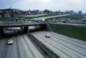
In contrast to harbors, local streets, and rails, neither highway nor airport development followed this private model. In the early twentieth century, with the influx of automobiles and prompted by the “good roads movement,” county governments built the region’s first reliable, asphalt trans-county and intercity roads. After World War Two, the federal government directed creation of an interstate expressway system—high speed roads with limited access. Major expressways in the Milwaukee area are I-94, I-41, I-43, and US 45, as well as the 794 and 894 spurs. While these expressways fostered rapid suburban development, they transected and thereby disrupted established neighborhoods and business patterns.[7]
Airports also benefited from major government backing. Milwaukee, Ozaukee, Washington, and Waukesha counties all initiated airport development in the early twentieth century, with airmail service to Milwaukee commencing in 1926. A year later, Milwaukee County purchased farmland south of the city and built the commercial airfield known today as General Mitchell International Airport, named after World War One pilot/hero William “Billy” Mitchell, grandson of railroad tycoon Alexander Mitchell.[8] A more recent, “green friendly” transportation investment is the extensive network of county-sponsored bicycle trails through parks, on river-flanked parkways, and along Milwaukee’s lakefront. Ozaukee County has also transformed abandoned interurban routes into extensive bike trails.[9]
Today the Wisconsin Department of Transportation oversees most transportation functions, primarily funded through tax dollars and license fees. Diesel buses mainly provide passenger transit, although Milwaukee broke ground on a new streetcar system in 2017.[10] The transportation history of metropolitan Milwaukee is representative of patterns throughout the United States in three important ways: many routes follow the paths of early settlers, shaped by geographical and technological limits; these routes in turn dictate present-day residential and business locations; and state and federal—not local—planners decide the types and placement of new transportation systems.
Footnotes [+]
- ^ Bayrd Still, Milwaukee: History of a City (Madison: State Historical Society of Wisconsin, 1948) 44-46; Wisconsin Marine Historical Society, Maritime Milwaukee (Charleston, SC: Arcadia Publishing, 2011).
- ^ Maritime Milwaukee, 7-27; History, General Mitchell International Airport website, last accessed June 2, 2017.
- ^ Still, Milwaukee, 51. The first of the plank roads, the Watertown Plank Road, was completed in 1847.
- ^ Still, Milwaukee, 207, 223-225. In the late 1800s, two companies, the Pere Marquette and the Grand Trunk, commenced ferry service across Lake Michigan, so that railroad cars might travel directly to Michigan while circumventing Chicago. John Kelley, “Lake Michigan Carferries,” Classic Trains Magazine, September 6, 2001, ctr.trains.com/railroad-reference/operations/2001/09/lake-Michigan-carferries, accessed 1/8/2015; Karen W. Moore, “Missed Connections: The ‘Progressive’ Derailment of Public Transit in Metropolitan Milwaukee during the Electric Streetcar Era (1890-1960)” (Ph.D. diss., University of Wisconsin-Milwaukee, 2011).
- ^ Still, Milwaukee, 360-361. In 1873, Wisconsin granted Milwaukee greater authority over such projects. During that time the city went from 25 to 40 bridges and 57 to 220 miles of paved roads. After a thorough study of other cities, the Common Council determined that Milwaukee streets should be paved with a type of brick called Telford macadam or with Medina sandstone, although many wooden pavements continued in use until the end of the 1800s. Another unique feature relating to Milwaukee roads is the network of “parkways” along the rivers and throughout the region. They were designed in the 1920s-1940s by city and county planner Charles Whitnall to retain the area’s natural beauty contiguous to residential neighborhoods.
- ^ Moore, “Missed Connections,” passim.
- ^ The original expressways were known as the East-West Freeway (now Interstate 94 built on the former Speedrail route) and the North-South Freeway (now Interstate-43). Interstates 43 and 94 today intersect at the Marquette Interchange near Marquette University, just west of Downtown, and I-45 crosses I-94 west of Milwaukee at the Zoo Interchange, thence joining with I-43 and the I-895 airport spur. Several of the city’s expressway projects never reached completion, either due to loss of funding or citizen protests. The Zoo Interchange and other improvements to I-94 have been the focus of recent litigation by transit advocates.
- ^ See History, General Mitchell International Airport website, last accessed June 2, 2017; and Southeast Wisconsin Regional Planning Corporation website, last accessed June 2, 2017.
- ^ The latest bike trail in Milwaukee County runs the length of the formerly industrial Menomonee Valley, connecting the city’s western suburbs of West Allis and Wauwatosa to Milwaukee’s lakefront. See “Wisconsin Bicycle Maps,” Wisconsin Department of Transportation website, http://www.dot.wisconsin.gov/travel/bike-foot/bikemaps.htm, now available at County Bicycle Maps, Wisconsin Department of Transportation website, last accessed June 2, 2017. Milwaukee County Transit System buses also sport bicycle racks for passenger use. “Bikes on Buses,” Milwaukee County Transit System website, last accessed June 2, 2017.
- ^ See Wisconsin Department of Transportation website, last accessed June 2, 2017, and the Milwaukee Streetcar website, last accessed June 2, 2017. Mary Spicuzza, “Milwaukee Streetcar Route Construction to Begin in April,” Milwaukee Journal Sentinel, February 17, 2017; “Milwaukee Streetcar Rails Installed along St. Paul Ave.,” Milwaukee Journal Sentinel, May 15, 2017, last accessed May 15, 2017.
For Further Reading
McShane, Clay. Technology and Reform: Street Railways and the Growth of Milwaukee, 1887-1900. Madison: State Historical Society of Wisconsin, 1974.
Moore Karen. “Missed Connections: The ‘Progressive’ Derailment of Public Transit in Metropolitan Milwaukee during the Electric Streetcar Era (1890-1960).” Ph.D. diss., University of Wisconsin-Milwaukee, 2011.
Still, Bayrd. Milwaukee: History of a City. Madison: State Historical Society of Wisconsin, 1948.
0 Comments
Please keep your community civil. All comments must follow the Encyclopedia of Milwaukee Community rules and terms of use, and will be moderated prior to posting. Encyclopedia of Milwaukee reserves the right to use the comments we receive, in whole or in part, and to use the commenter's name and location, in any medium. See also the Copyright, Privacy, and Terms & Conditions.
Have a suggestion for a new topic? Please use the Site Contact Form.