The Town of Farmington occupies the northeast corner of Washington County. It borders Sheboygan County to the north and Ozaukee County to the east.[1] Originally, the Town of Farmington was part of the Town of West Bend, though in 1847 an act of the territorial legislature set off a piece of land, first called Clarence. On March 11, 1848, the municipality was given its current name, the Town of Farmington.[2] The Town contains several hamlets, including Cheeseville, Boltonville, Fillmore, and St. Michaels. These hamlets were established in the early days of the Town settlement.
Between 1880 until 1950, the population of the Town of Farmington remained stable, with between 1,200 and 1,800 residents total.[3] None of the small settlements grew enough to warrant incorporation. The late twentieth and early twenty-first centuries saw sizable growth for the Town, however, and of the thirteen townships in Washington County, the Town of Farmington experienced nearly the most substantial development. The Town expanded from 2,523 in 1990 to 3,239 in 2000, an increase of nearly thirty percent. Within Washington County, only the Town of Erin had more significant population growth in the same period of time.[4] From its early days, farming, particularly dairy farming, played a central role in the Town’s economy.[5] About 60% of the land in Farmington remains in agricultural use in the twenty-first century.[6]
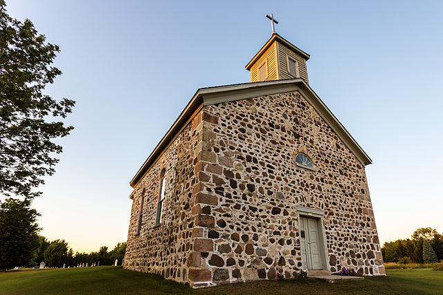
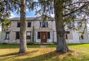
The Town of Farmington is home to several entries on the National Register of Historic Places. Of the twenty-six entries on the Register in Washington County, four are located within the Town of Farmington. Entries include: Saxonia House; St. John of God Roman Catholic Church, Convent, and School; St. Peter’s Church; and Lizard Mound County Park.[7]
Also listed on the State of Wisconsin’s Register of Historic Places, Lizard Mound Park makes up thirty-one acres of Town land and is part of the Washington County “Island” Effigy Mound District.[8] The effigy mounds in Lizard Mound County Park were constructed between 650 and 1300 CE[9] and served as burial sites. In the 1960s, archaeologists excavated numerous artifacts, including pots, tools, and beads. Thirty-one mounds are preserved in the present day, though there were originally as many as sixty in the group. The mounds are a variety of earthworks shapes, representing both animal and geometric forms, and are constructed of mounded earth about three-and-a-half feet high.[10]
The Town of Farmington is home to a multitude of waterways, including the North Branch of the Milwaukee River, Wallace Creek, and Stony Creek. The land is also dotted with numerous lakes and ponds, including Lake Twelve and Green Lake, the largest of these within the Town limits. Wetlands surround many of these bodies of water.[11]
Footnotes [+]
- ^ Southeastern Wisconsin Regional Planning Commission, A Comprehensive Plan for the Town of Farmington: 2035 (Waukesha, WI: Southeastern Wisconsin Regional Planning Committee, 2010), 18, last accessed August 5, 2017.
- ^ Western Historical Company, History of Washington and Ozaukee Counties, Wisconsin (Chicago, IL: Western Historical Company, 1881), 428.
- ^ Southeastern Wisconsin Regional Planning Commission, A Comprehensive Plan for the Town of Farmington, 39.
- ^ Southeastern Wisconsin Regional Planning Commission, A Comprehensive Plan for the Town of Farmington, 38.
- ^ Western Historical Company, History of Washington and Ozaukee Counties, 428.
- ^ Southeastern Wisconsin Regional Planning Commission, A Comprehensive Plan for the Town of Farmington, 60.
- ^ “Saxonia House, National Register of Historic Places Inventory—Nomination Form,” National Park Service, accessed November 18, 2015; “St. John of God Roman Catholic Church, Convent, and School, National Register of Historic Places Inventory—Nomination Form,” National Park Service, accessed November 18, 2015; “St. Peter’s Church, National Register of Historic Places Inventory—Nomination Form,” National Park Service, accessed November 18, 2015; “Lizard Mound State Park, National Register of Historic Places Inventory—Nomination Form,” National Park Service, accessed November 18, 2015.
- ^ Southeastern Wisconsin Regional Planning Commission, A Comprehensive Plan for the Town of Farmington, 81-82.
- ^ Photograph of Marker, Lizard Mound Park, Wisconsinmounds.com, last accessed August 5, 2017.
- ^ Dean R. Snow, “Lizard Mound,” Archaeology of Native North America (New York, NY: Routledge, 2010), 109; “Lizard Mound State Park, National Register of Historic Places Inventory—Nomination Form,” National Park Service, accessed November 18, 2015.
- ^ Southeastern Wisconsin Regional Planning Commission, A Comprehensive Plan for the Town of Farmington, 68.
For Further Reading
Footprints through Farmington. Farmington, WI: Farmington Historical Society, Inc., 2001.
0 Comments
Please keep your community civil. All comments must follow the Encyclopedia of Milwaukee Community rules and terms of use, and will be moderated prior to posting. Encyclopedia of Milwaukee reserves the right to use the comments we receive, in whole or in part, and to use the commenter's name and location, in any medium. See also the Copyright, Privacy, and Terms & Conditions.
Have a suggestion for a new topic? Please use the Site Contact Form.